
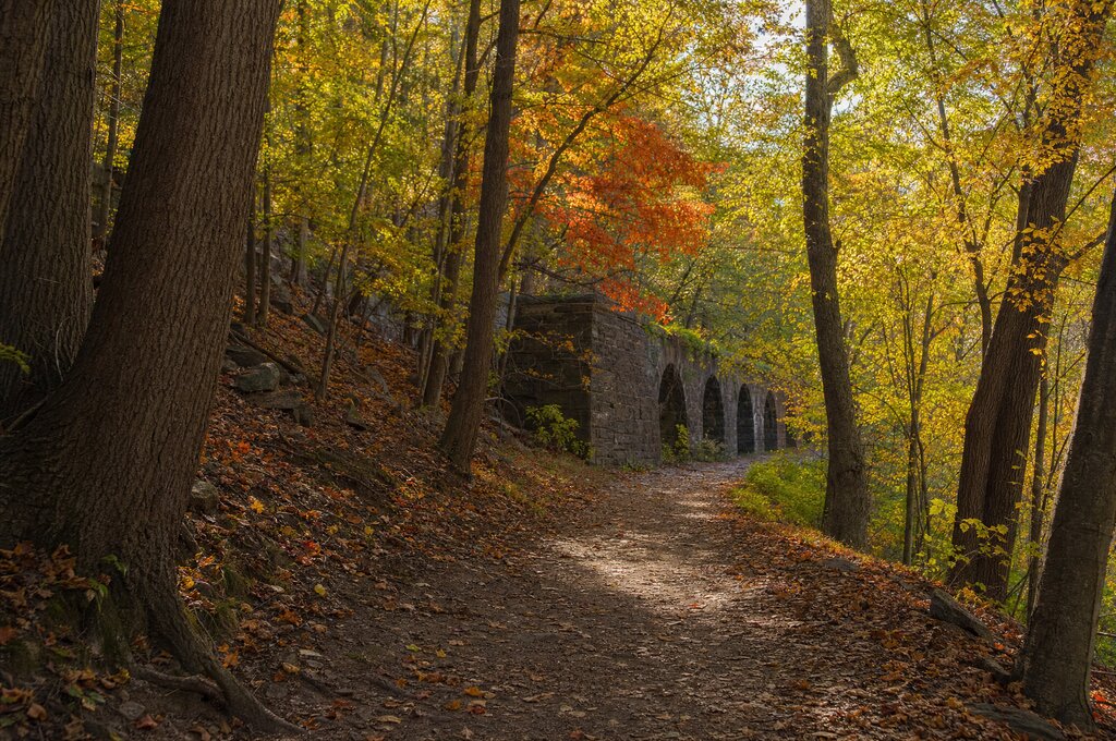
There's a moment, somewhere around mile three, where the trail dips below street level and the noise of Westchester's roads disappears. You're walking on top of a 170-year-old tunnel that once carried every drop of New York City's drinking water, and the only sounds are your footsteps and the wind through oaks that were saplings when the aqueduct was built. That's when you understand why this trail is the best thing in Westchester that most residents have never fully explored.
The Old Croton Aqueduct Trail runs roughly 26 miles from the New Croton Dam in Cortlandt down to the Bronx border in Yonkers. It's not a wilderness hike — it passes through nine villages and towns, crossing backyards and skirting streets — but that's exactly what makes it fascinating. You see Westchester from an angle you can't get from any road: the back of every village, the places where the forest takes over, and the stone ventilators that still stand like sentries along the route.
We walked the entire trail over four separate weekends. Here's our village-by-village breakdown, with where to park, where to eat, and the landmarks most hikers walk right past.
Croton-on-Hudson to Ossining: The Beginning
The trail's northern trailhead sits at the New Croton Dam, a structure so massive it's worth visiting even if you never set foot on the trail. Park at the Croton Dam Plaza lot on Route 129. The first three miles are the trail's most wooded and secluded section, dropping you through hardwood forest before emerging near the Route 9 bridge.
The must-see landmark here is the Croton Dam overlook — take the short spur path near the trailhead for a view of the 200-foot spillway. Most people skip this and start walking immediately. Don't.
When you reach Ossining, take a detour down to the waterfront. The Double O Arch — the aqueduct's most impressive above-ground structure — is visible from the trail just before you hit the village center. Grab lunch at one of the restaurants along Main Street; there are good options for both quick bites and sit-down meals.
Ossining to Tarrytown: The River Views
This five-mile stretch is where the trail earns its reputation. The path stays high on the bluff above the Hudson, and on a clear day you can see the Palisades cliffs on the New Jersey side. It's the most scenic section of the entire route.
Park at the Old Dutch Church lot in Sleepy Hollow if you want to start here (check for event closures — the lot fills up during the fall Haunted Hayride season). Walk north or south; either direction delivers river views.
The hidden gem on this section is the Lyndhurst wall. About a mile south of Tarrytown, the trail runs along a massive stone wall that borders the Lyndhurst estate. Look for the ornate iron gate set into the wall — it's one of the most photographed spots on the trail, but you have to know to look for it.
In Tarrytown, the trail passes directly behind the Warner Library. Walk down Main Street for coffee or lunch, then pick the trail back up near the Losee Park parking lot. If you're interested in the area's literary history, read our guide to waterfront dining along the Hudson for restaurant recommendations with river views.
Tarrytown to Hastings-on-Hudson: The Middle Miles
This four-mile section is quieter and more residential than the river-view stretch to the north, but it has its own character. The trail passes through the back of several neighborhoods and crosses a few roads, but the sense of being on a hidden corridor through the county never leaves.
Park at the South County Trailway lot in Hastings. The village itself is worth exploring — it has one of the best small-town main streets in Westchester, with independent shops and good coffee. If you're doing a coffee-focused trip, check out our Sound Shore coffee crawl for a different take on the county's caffeine scene.
The notable landmark here is the ventilator No. 12, a small stone structure that looks like a miniature castle. It's one of the best-preserved ventilators on the trail and sits right on the path — you can't miss it, but most hikers don't know what they're looking at. These ventilators once equalized air pressure in the tunnel below.
Hastings to Yonkers: The Final Push
The southernmost five miles of the trail pass through Yonkers, where the aqueduct's history becomes most visible. The trail runs through Tibbetts Brook Park (see our guide to Tibbetts Brook Park for everything that park offers beyond the trail) and past the Untermyer Gardens, which are worth a detour even if you're trying to make mileage.
Park at the Untermyer Gardens lot on North Broadway. This section can be confusing because the trail crosses several major roads — use the Friends of the Old Croton Aqueduct map or the AllTrails app to navigate. The trail technically ends at the Bronx border, but most walkers turn around at the Yonkers waterfront, where you can reward yourself with lunch and a view.
Practical Information
Trail Surface and Difficulty
The entire trail is an unpaved dirt path — no pavement, no gravel. It's wide enough for two people to walk side by side in most sections, and the elevation change is minimal (the aqueduct maintained a precise gradient for gravity flow). It's suitable for all fitness levels, though the full 26 miles in one day is a serious undertaking.
The trail is not paved and can be muddy after rain. Wear hiking shoes or sturdy sneakers. In summer, bring water — there are no fountains on the trail itself, though you can find them in each village.
Best Times to Walk
- Spring (April–May): Wildflowers along the trail, comfortable temperatures, minimal bugs.
- Fall (October–November): Peak foliage, especially in the northern sections. See our fall foliage drives guide for complementary scenic routes.
- Winter: The trail is beautiful after snow, but icy sections can be dangerous. Microspikes recommended.
- Summer: Fully shaded in most sections, but humid. Start early.
Parking by Section
- Northern trailhead: Croton Dam Plaza lot, Route 129, Cortlandt
- Ossining: Nelson Avenue parking near the aqueduct arch
- Sleepy Hollow: Old Dutch Church lot (check for event closures)
- Tarrytown: Losee Park lot, off Route 9
- Hastings: South County Trailway lot, Saw Mill River Road
- Yonkers: Untermyer Gardens lot, North Broadway
What to Bring
The trail passes through villages frequently, so you're never far from food or water. Still, bring: a water bottle, a trail map (cell service is generally good but not perfect), insect repellent in summer (ticks are present — see our disclaimer for outdoor activity risks), and comfortable shoes. A small backpack is plenty for a section walk.
If you only have time for one section, walk from Tarrytown to Hastings. It delivers the best river views, the most varied terrain, and two great villages for refueling.
Why This Trail Matters
The Old Croton Aqueduct isn't just a trail — it's the reason New York City grew into the metropolis it became. Before the aqueduct was completed in 1842, the city's water supply was inadequate and increasingly polluted. The Croton River, 40 miles north, was the solution, and the aqueduct carried its water by gravity alone — a feat of engineering that still works today (the tunnel is intact and could theoretically carry water again).
Walking the trail is walking through that history. Every stone ventilator, every arch, every tunnel entrance is a piece of infrastructure that changed the trajectory of the largest city in America. That's what makes it more than a hike — it's a linear museum, and Westchester is lucky to have it running through its backyards.
For more Westchester trail coverage, see our guide to the Saw Mill River Greenway for cyclists or our exploration of the Rockwood Hall ruins at Rockefeller State Park.